
Generates animated map videos and data visualizations from text prompts or JSON descriptions for use in explainers and documentaries.
Also known as 21prnv/mapcast
- Stars
- 5
- Tools
- —
- Downloads, 30 days
- —
- Latest version
- 0.1.1
- Last commit
- Nov 2, 2026
- License
- MIT
What is mapcast MCP?
mapcast generates animated map videos and data visualizations from text prompts or JSON descriptions for use in explainers and documentaries.
Summary generated from the project's README
About mapcast MCP server
Creating animated map videos for documentaries or social media shorts is possible through this tool by using text prompts or JSON descriptions. It allows users to highlight specific countries, states, or provinces using various styles like solid tints, outlines, or even laying a national flag over the terrain. The server supports diverse basemaps including NASA Blue Marble, Sentinel-2 satellite imagery, and old parchment styles.
Designed specifically for AI agents, the server can be integrated into MCP clients like Claude Desktop, Cursor, or Windsurf. It provides two primary tools: render_map for generating full videos or images and preview_map for checking a single frame before a complete render. Users must have ffmpeg installed on their local system, and the initial setup will download Chromium and necessary map data. The system can produce multiple formats including MP4, GIF, PNG, and JPG in various aspect ratios like 16:9 or 9:16.
What you can do with it
- 1Generate social media map shortsCreate a vertical video that spins the globe and lands on a specific country with its flag.
- 2Visualize geographic data distributionsProduce a map that colors different countries based on specific numerical values like unemployment or GDP.
- 3Create historical style mapsRender an old parchment map with specific cities marked for educational content.
Written from the project's README. Every use case is checked against a quote from it.
How to install mapcast MCP
Formats verified 10 Nov 2026Install mapcast MCP in Claude Code
$ claude mcp add mapcast -- npx -y mapcastInstall mapcast MCP in Cursor
~/.cursor/mcp.json
{
  "mcpServers": {
    "mapcast": {
      "command": "npx",
      "args": [
        "-y",
        "mapcast"
      ]
    }
  }
}Install mapcast MCP in VS Code
.vscode/mcp.json
{
  "servers": {
    "mapcast": {
      "type": "stdio",
      "command": "npx",
      "args": [
        "-y",
        "mapcast"
      ]
    }
  }
}Install mapcast MCP in Claude Desktop
claude_desktop_config.json
{
  "mcpServers": {
    "mapcast": {
      "command": "npx",
      "args": [
        "-y",
        "mapcast"
      ]
    }
  }
}Install mapcast MCP in Codex
~/.codex/config.toml
[mcp_servers.mapcast]
command = "npx"
args = ["-y", "mapcast"]
Install mapcast MCP in Gemini CLI
~/.gemini/settings.json
{
  "mcpServers": {
    "mapcast": {
      "command": "npx",
      "args": [
        "-y",
        "mapcast"
      ]
    }
  }
}Automated checks
Ran Nov 14, 2026Full report →Passed our automated checks. That is not a security audit: read the code and give the server the narrowest access it needs. How checks work

- Source repository linked and reachable21prnv/mapcast is public and reachablegithub.com/21prnv/mapcast ↗Pass
- Package names this repository as its sourcemapcast names 21prnv/mapcast as sourcenpmjs.com/package/mapcast ↗Pass
- Build provenance (Sigstore attestation)Sigstore attestation for mapcastnpmjs.com/package/mapcast/v/0.1.1#provenance ↗Pass
- Open source license (OSI)MITspdx.org/licenses/MIT.html ↗Pass
- Commit or release in the last yearLast commit or release 2026-11-02github.com/21prnv/mapcast ↗Pass
- OpenSSF ScorecardNot checked
- Package name not close to a popular packageNo popular package one edit away from mapcastPass
- No critical advisory in the package or its dependencies103 resolved dependencies checked; no critical advisoryosv.dev ↗Pass
- No hidden instructions to the model0 tool descriptions and the README read; no override phrases, credential paths or hidden charactersPass
- Destructive tools are labelledNot checked
- Remote endpoint answers the MCP handshakeNot checked
README
View on GitHubmapcast
Animated map videos for explainers, documentaries and Shorts, from one line of JSON. Highlight any country, state or province on real satellite imagery or an old paper map: tracing borders, flags, glow, labels, capitals, data colours, a 3D globe dive and camera flights between countries. Free, open source, and built for AI agents to drive.


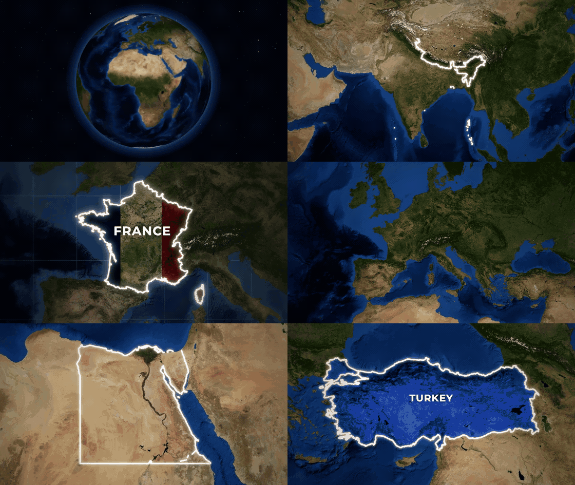
Full-quality version: docs/showcase.mp4
npx mapcast quick India -o india.mp4
That is the whole setup. The first run downloads Chromium and map data once (both cached); videos also need ffmpeg.
Ask your AI for it
mapcast is made to be driven by AI tools: you describe the map, the agent writes the scene, mapcast renders it.
"Make a YouTube Short that spins the globe and lands on Brazil with its flag." "Old parchment map of Turkey, zooming in, with Istanbul marked." "Colour these countries by unemployment: Spain 11.4, Greece 9.8, Germany 3.4."
Claude Code (skill and MCP server in one install):
/plugin marketplace add 21prnv/mapcast
/plugin install mapcast@mapcast
Claude Desktop, Cursor, Windsurf, Codex or any MCP client: add this to the client's MCP config.
{
  "mcpServers": {
    "mapcast": { "command": "npx", "args": ["-y", "mapcast", "mcp"] }
  }
}
The server offers render_map (saves the video or image and returns a preview of the final frame, so the agent
can check its work) and preview_map (one frame, to check a scene before rendering). Every option is described
in the tool schema.
Agents that read SKILL.md skills: npx skills add 21prnv/mapcast. The skill is in
skills/mapcast, with 27 worked request-to-scene examples.
What it can do
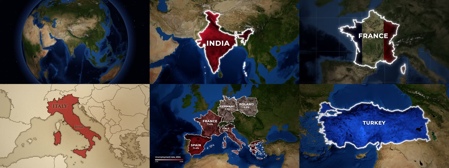
- Styles: colour tint that keeps the terrain visible, spotlight (rest of the world turns grey), outline, or the country's flag laid over its land.
- Basemaps: NASA Blue Marble and Sentinel-2 satellite imagery, or an old parchment map with engraved coasts.
- Cameras: slow push-in, zoom in from a wide view, dive from a spinning 3D globe, fly from country to country.
- Places: every country by name or ISO code, plus 4,500 states and provinces (
"California","IN-MH"), with capitals or any city marked. - Data maps: colour countries by a number with a legend, with names and values on the map.
- Formats: MP4, GIF, PNG, JPG in 16:9, 9:16, 1:1 or 4:5.
- Disputed borders: drawn the way the highlighted country officially draws them, or a neutral view on request.
Command line
npx mapcast quick "United States" --style highlight --color yellow -o usa.png
npx mapcast quick France --style flag -o france.mp4
npx mapcast quick Brazil --camera globe -o brazil.mp4          # dive in from a spinning Earth
npx mapcast quick India France Japan --camera fly -o tour.mp4   # fly from country to country
npx mapcast quick Italy --basemap paper -o italy.mp4

npx mapcast render scene.json -o out.mp4        # any scene; .mp4, .gif, .png or .jpg
npx mapcast render scene.json -o out.png --at 1.2
cat scene.json | npx mapcast render - -o out.gif
npx mapcast schema                              # the scene format as JSON Schema
npx mapcast mcp                                 # MCP server on stdio
Every file in examples/ renders as-is.
Scene format
{
  "aspect": "16:9",
  "duration": 5,
  "camera": "push-in",
  "highlights": [
    { "country": "India", "style": "solid", "color": "#c8102e", "label": "INDIA" }
  ]
}
| Field | Values | Default |
|---|---|---|
aspect |
16:9, 9:16, 1:1, 4:5 (or set width/height) |
16:9 |
duration |
seconds | 5 (7 for globe, 1 + 3 per country for fly) |
fps |
frames per second | 30 |
camera |
push-in, zoom-in, globe (3D Earth dive), fly (country to country), static, or { "move", "fill", "from" } |
push-in |
basemap |
satellite, bluemarble, sentinel, paper (old parchment map) |
satellite |
pov |
auto (the country's own official borders), default, or a code like ind, chn, pak |
auto |
effects.grade |
natural, muted, mono |
natural |
effects.vignette |
0 to 1 | 0.45 |
effects.blur |
0 to 1: soft-focus edges, like a camera lens | 0 |
effects.grid |
true or { "step", "color", "opacity" }: lat/long grid over the sea only |
off |
effects.borders |
true: thin borders of neighbouring countries |
on for paper and states |
labelAnim |
default label animation for every highlight | rise |
Each highlight:
| Field | Values | Default |
|---|---|---|
country |
name ("India") or ISO code ("IN", "IND") |
country or region required |
region |
a state or province: "California", "Bavaria", "US-CA", "IN-MH" |
|
style |
solid (tinted fill), highlight (rest of the world goes grey), outline, flag (the country's flag over the terrain) |
solid |
color |
any CSS colour or red, yellow, blue, ... |
a distinct colour per country |
label |
text, or false for none |
the country name |
border |
{ "color", "width", "glow" } or false |
white, glowing |
labelAnim |
rise, type (typewriter), spread (letters close in), slide, pop |
rise |
labelSize |
multiplier on the automatic label size, e.g. 0.7 or 1.3 |
1 |
labelFont |
sans, serif, or any font name |
sans (serif on paper) |
capital |
true for the capital (a state's own capital for region), or a city name like "Mumbai" |
off |
start |
seconds when this country starts animating | staggered automatically |
Data maps
Colour countries by a number, with a legend:
{
  "data": {
    "title": "GDP 2024 (trillion US$)",
    "prefix": "$",
    "unit": "T",
    "scheme": "heat",
    "values": { "India": 3.9, "China": 18.7, "Japan": 4.1 }
  }
}
scheme is one of reds, blues, greens, heat, purples, diverging, or a list of colours.
Set "labels" to "name", "value" (the number with prefix/unit) or "both" to label each country,
and min/max to fix the colour range. A highlight's label can have a second line: "INDIA\n1.4 BILLION".
How it works
A scene is resolved against Natural Earth borders, the imagery tiles the camera path needs are fetched and cached, and a headless Chromium draws each frame on a canvas (WebGL for the globe). Frames are piped to ffmpeg. A 5 second 1080p clip takes about 15 seconds on a laptop.
Credits and licence
MIT. Map data, imagery and font licences are in NOTICE.md. Satellite imagery needs a credit line wherever you publish; mapcast prints the exact line after every render.
Contributions are welcome: see CONTRIBUTING.md.
mapcast MCP questions
How do I add mapcast MCP to Claude Code?
Run claude mcp add mapcast -- npx -y mapcast in your terminal. Add --scope user to make it available in every project.
How do I add mapcast MCP to Cursor?
Open ~/.cursor/mcp.json and add the server under mcpServers, using the Cursor config shown in the install section above.
How can I use mapcast with an AI agent?
You can add it to MCP clients like Claude Desktop, Cursor, or Windsurf by adding the server to your MCP configuration.
What kind of map styles are available?
Available styles include color tints, spotlights that grey out the rest of the world, outlines, and overlaying a country's flag onto its land.
Can I create data-driven maps?
Yes, you can color countries by numerical values using various color schemes and include a legend with titles and units.
What file formats does it support?
The tool supports rendering videos and images in MP4, GIF, PNG, and JPG formats.