
テキストプロンプトやJSON形式の記述から、解説動画やドキュメンタリー向けの動的な地図動画およびデータ視覚化を生成します。
別名 21prnv/mapcast
- スター
- 6
- ツール
- —
- ダウンロード数(30日間)
- —
- 最新バージョン
- 0.1.1
- 最終コミット
- 2026年11月2日
- ライセンス
- MIT
mapcast MCPとは
テキストプロンプトやJSON形式の記述から、解説動画やドキュメンタリー向けの動的な地図動画およびデータ視覚化を生成します。
プロジェクトのREADMEから生成された概要
mapcast MCP server について
このツールを使用すると、テキストプロンプトやJSON形式の記述を用いて、ドキュメンタリーやソーシャルメディアのショート動画用の動的な地図動画を作成できます。単色での塗りつぶし、アウトライン、あるいは地形の上に国旗を重ねるなど、さまざまなスタイルを使用して特定の国、州、または地域を強調表示できます。このサーバーは、NASA Blue Marble、Sentinel-2衛星画像、古い羊皮紙スタイルなど、多様なベースマップをサポートしています。
AIエージェント向けに特別に設計されたこのサーバーは、Claude Desktop、Cursor、WindsurfなどのMCPクライアントに統合できます。主に2つのツールを提供します。フルサイズのビデオや画像を生成するrender_mapと、完全なレンダリングの前に単一のフレームを確認するpreview_mapです。ユーザーはローカルシステムにffmpegをインストールしておく必要があり、初回セットアップ時にChromiumと必要な地図データがダウンロードされます。システムは、16:9や9:16などのさまざまなアスペクト比で、MP4、GIF、PNG、JPGを含む複数の形式を生成できます。
できること
- 1ソーシャルメディア向けの地図ショート動画生成地球儀が回転し、特定の国に止まってその国の国旗が表示される縦型動画を作成します。
- 2地理データの分布の視覚化失業率やGDPなどの特定の数値に基づいて、異なる国を色分けした地図を作成します。
- 3歴史的なスタイルの地図作成教育コンテンツ向けに、特定の都市がマークされた古い羊皮紙風の地図をレンダリングします。
プロジェクトの README から作成されています。すべてのユースケースは、その引用と照らし合わせて確認されています。
mapcast MCPのインストール方法
フォーマット検証日 2026年11月10日Cursor に追加Gooseに追加Claude Codeにmapcast MCPをインストール
$ claude mcp add mapcast -- npx -y mapcastCursorにmapcast MCPをインストール
~/.cursor/mcp.json
{
  "mcpServers": {
    "mapcast": {
      "command": "npx",
      "args": [
        "-y",
        "mapcast"
      ]
    }
  }
}VS Codeにmapcast MCPをインストール
.vscode/mcp.json
{
  "servers": {
    "mapcast": {
      "type": "stdio",
      "command": "npx",
      "args": [
        "-y",
        "mapcast"
      ]
    }
  }
}VS Code CLIにmapcast MCPをインストール
$ code --add-mcp '{"name":"mapcast","type":"stdio","command":"npx","args":["-y","mapcast"]}'Claude Desktopにmapcast MCPをインストール
claude_desktop_config.json
{
  "mcpServers": {
    "mapcast": {
      "command": "npx",
      "args": [
        "-y",
        "mapcast"
      ]
    }
  }
}Codexにmapcast MCPをインストール
$ codex mcp add mapcast -- npx -y mapcastCodex config.tomlにmapcast MCPをインストール
~/.codex/config.toml
[mcp_servers.mapcast]
command = "npx"
args = ["-y", "mapcast"]
Gemini CLIにmapcast MCPをインストール
$ gemini mcp add -s user mapcast npx -- -y mapcastGemini settings.jsonにmapcast MCPをインストール
~/.gemini/settings.json
{
  "mcpServers": {
    "mapcast": {
      "command": "npx",
      "args": [
        "-y",
        "mapcast"
      ]
    }
  }
}自動チェック
実行日 2026年11月14日完全なレポート →自動チェックに合格しました。これはセキュリティ監査ではありません。コードを読み、サーバーに必要最小限のアクセス権を与えてください。 チェックの仕組み

- ソースリポジトリがリンクされており、アクセス可能21prnv/mapcast is public and reachablegithub.com/21prnv/mapcast ↗合格
- パッケージがこのリポジトリをソースとして指定mapcast names 21prnv/mapcast as sourcenpmjs.com/package/mapcast ↗合格
- ビルドの来歴 (Sigstore 証明)Sigstore attestation for mapcastnpmjs.com/package/mapcast/v/0.1.1#provenance ↗合格
- オープンソースライセンス (OSI)MITspdx.org/licenses/MIT.html ↗合格
- 過去1年以内にコミットまたはリリースありLast commit or release 2026-11-02github.com/21prnv/mapcast ↗合格
- OpenSSF Scorecard未チェック
- パッケージ名が有名なパッケージに酷似していないNo popular package one edit away from mapcast合格
- パッケージおよびその依存関係に重大な勧告なし103 resolved dependencies checked; no critical advisoryosv.dev ↗合格
- モデルへの隠れた指示がない0 tool descriptions and the README read; no override phrases, credential paths or hidden characters合格
- 破壊的なツールがラベル付けされている未チェック
- リモートエンドポイントが MCP ハンドシェイクに応答未チェック
README
GitHubで見るmapcast
Animated map videos for explainers, documentaries and Shorts, from one line of JSON. Highlight any country, state or province on real satellite imagery or an old paper map: tracing borders, flags, glow, labels, capitals, data colours, a 3D globe dive and camera flights between countries. Free, open source, and built for AI agents to drive.


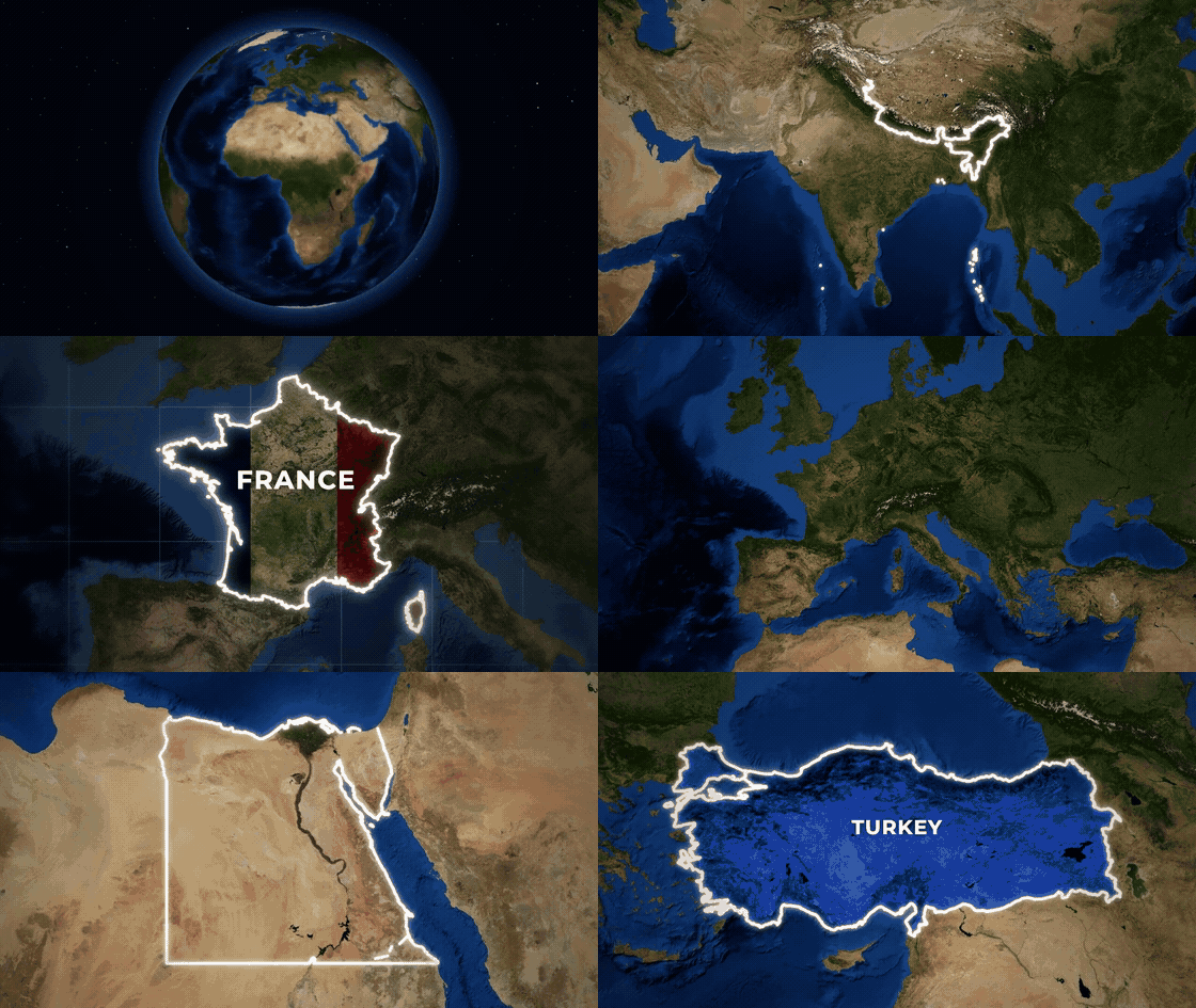
Full-quality version: docs/showcase.mp4
npx mapcast quick India -o india.mp4
That is the whole setup. The first run downloads Chromium and map data once (both cached); videos also need ffmpeg.
Ask your AI for it
mapcast is made to be driven by AI tools: you describe the map, the agent writes the scene, mapcast renders it.
"Make a YouTube Short that spins the globe and lands on Brazil with its flag." "Old parchment map of Turkey, zooming in, with Istanbul marked." "Colour these countries by unemployment: Spain 11.4, Greece 9.8, Germany 3.4."
Claude Code (skill and MCP server in one install):
/plugin marketplace add 21prnv/mapcast
/plugin install mapcast@mapcast
Claude Desktop, Cursor, Windsurf, Codex or any MCP client: add this to the client's MCP config.
{
  "mcpServers": {
    "mapcast": { "command": "npx", "args": ["-y", "mapcast", "mcp"] }
  }
}
The server offers render_map (saves the video or image and returns a preview of the final frame, so the agent
can check its work) and preview_map (one frame, to check a scene before rendering). Every option is described
in the tool schema.
Agents that read SKILL.md skills: npx skills add 21prnv/mapcast. The skill is in
skills/mapcast, with 27 worked request-to-scene examples.
What it can do
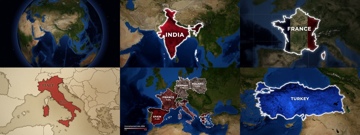
- Styles: colour tint that keeps the terrain visible, spotlight (rest of the world turns grey), outline, or the country's flag laid over its land.
- Basemaps: NASA Blue Marble and Sentinel-2 satellite imagery, or an old parchment map with engraved coasts.
- Cameras: slow push-in, zoom in from a wide view, dive from a spinning 3D globe, fly from country to country.
- Places: every country by name or ISO code, plus 4,500 states and provinces (
"California","IN-MH"), with capitals or any city marked. - Data maps: colour countries by a number with a legend, with names and values on the map.
- Formats: MP4, GIF, PNG, JPG in 16:9, 9:16, 1:1 or 4:5.
- Disputed borders: drawn the way the highlighted country officially draws them, or a neutral view on request.
Command line
npx mapcast quick "United States" --style highlight --color yellow -o usa.png
npx mapcast quick France --style flag -o france.mp4
npx mapcast quick Brazil --camera globe -o brazil.mp4          # dive in from a spinning Earth
npx mapcast quick India France Japan --camera fly -o tour.mp4   # fly from country to country
npx mapcast quick Italy --basemap paper -o italy.mp4

npx mapcast render scene.json -o out.mp4        # any scene; .mp4, .gif, .png or .jpg
npx mapcast render scene.json -o out.png --at 1.2
cat scene.json | npx mapcast render - -o out.gif
npx mapcast schema                              # the scene format as JSON Schema
npx mapcast mcp                                 # MCP server on stdio
Every file in examples/ renders as-is.
Scene format
{
  "aspect": "16:9",
  "duration": 5,
  "camera": "push-in",
  "highlights": [
    { "country": "India", "style": "solid", "color": "#c8102e", "label": "INDIA" }
  ]
}
| Field | Values | Default |
|---|---|---|
aspect |
16:9, 9:16, 1:1, 4:5 (or set width/height) |
16:9 |
duration |
seconds | 5 (7 for globe, 1 + 3 per country for fly) |
fps |
frames per second | 30 |
camera |
push-in, zoom-in, globe (3D Earth dive), fly (country to country), static, or { "move", "fill", "from" } |
push-in |
basemap |
satellite, bluemarble, sentinel, paper (old parchment map) |
satellite |
pov |
auto (the country's own official borders), default, or a code like ind, chn, pak |
auto |
effects.grade |
natural, muted, mono |
natural |
effects.vignette |
0 to 1 | 0.45 |
effects.blur |
0 to 1: soft-focus edges, like a camera lens | 0 |
effects.grid |
true or { "step", "color", "opacity" }: lat/long grid over the sea only |
off |
effects.borders |
true: thin borders of neighbouring countries |
on for paper and states |
labelAnim |
default label animation for every highlight | rise |
Each highlight:
| Field | Values | Default |
|---|---|---|
country |
name ("India") or ISO code ("IN", "IND") |
country or region required |
region |
a state or province: "California", "Bavaria", "US-CA", "IN-MH" |
|
style |
solid (tinted fill), highlight (rest of the world goes grey), outline, flag (the country's flag over the terrain) |
solid |
color |
any CSS colour or red, yellow, blue, ... |
a distinct colour per country |
label |
text, or false for none |
the country name |
border |
{ "color", "width", "glow" } or false |
white, glowing |
labelAnim |
rise, type (typewriter), spread (letters close in), slide, pop |
rise |
labelSize |
multiplier on the automatic label size, e.g. 0.7 or 1.3 |
1 |
labelFont |
sans, serif, or any font name |
sans (serif on paper) |
capital |
true for the capital (a state's own capital for region), or a city name like "Mumbai" |
off |
start |
seconds when this country starts animating | staggered automatically |
Data maps
Colour countries by a number, with a legend:
{
  "data": {
    "title": "GDP 2024 (trillion US$)",
    "prefix": "$",
    "unit": "T",
    "scheme": "heat",
    "values": { "India": 3.9, "China": 18.7, "Japan": 4.1 }
  }
}
scheme is one of reds, blues, greens, heat, purples, diverging, or a list of colours.
Set "labels" to "name", "value" (the number with prefix/unit) or "both" to label each country,
and min/max to fix the colour range. A highlight's label can have a second line: "INDIA\n1.4 BILLION".
How it works
A scene is resolved against Natural Earth borders, the imagery tiles the camera path needs are fetched and cached, and a headless Chromium draws each frame on a canvas (WebGL for the globe). Frames are piped to ffmpeg. A 5 second 1080p clip takes about 15 seconds on a laptop.
Credits and licence
MIT. Map data, imagery and font licences are in NOTICE.md. Satellite imagery needs a credit line wherever you publish; mapcast prints the exact line after every render.
Contributions are welcome: see CONTRIBUTING.md.
mapcast MCPのよくある質問
mapcast MCPをClaude Codeに追加するには
ターミナルでclaude mcp add mapcast -- npx -y mapcastを実行します。すべてのプロジェクトで利用するには--scope userを追加します。
mapcast MCPをCursorに追加するには
~/.cursor/mcp.jsonを開き、上記のインストールセクションに示すCursor設定を使ってmcpServersの下にサーバーを追加します。
AIエージェントでmapcastを使用するにはどうすればよいですか?
MCP設定にサーバーを追加することで、Claude Desktop、Cursor、WindsurfなどのMCPクライアントに追加できます。
どのような地図スタイルが利用可能ですか?
カラーティント、世界中の他の部分をグレーアウトするスポットライト、アウトライン、国の国旗を領土上にオーバーレイするスタイルなどが利用可能です。
データに基づいた地図を作成できますか?
はい、さまざまな配色を使用して数値に基づいて国を色分けしたり、タイトルや単位を含む凡例を追加したりできます。
サポートされているファイル形式は何ですか?
このツールは、MP4、GIF、PNG、JPG形式でのビデオおよび画像のレンダリングをサポートしています。