
Metin istemleri veya JSON açıklamaları kullanarak açıklayıcı videolar ve belgeseller için animasyonlu harita videoları ve veri görselleştirmeleri oluşturur.
Ayrıca bilinen adı 21prnv/mapcast
- Yıldızlar
- 6
- Araçlar
- —
- İndirmeler, 30 gün
- —
- En son sürüm
- 0.1.1
- Son commit
- 2 Kas 2026
- Lisans
- MIT
mapcast MCP nedir?
mapcast bir MCP sunucusudur. Metin istemleri veya JSON açıklamaları kullanarak açıklayıcı videolar ve belgeseller için animasyonlu harita videoları ve veri görselleştirmeleri oluşturur.
Özet, projenin README dosyasından oluşturuldu
mapcast MCP sunucusu hakkında
Belgeseller veya sosyal medya kısa videoları için animasyonlu harita videoları oluşturmak, bu araç sayesinde metin istemleri veya JSON açıklamaları kullanılarak mümkündür. Kullanıcıların; düz renk tonları, dış hatlar veya bir ulusal bayrağı arazi üzerine yerleştirme gibi çeşitli stiller kullanarak belirli ülkeleri, eyaletleri veya illeri vurgulamasına olanak tanır. Sunucu; NASA Blue Marble, Sentinel-2 uydu görüntüleri ve eski parşömen stilleri dahil olmak üzere çeşitli temel haritaları destekler.
Özellikle AI agent'lar için tasarlanan sunucu; Claude Desktop, Cursor veya Windsurf gibi MCP istemcilerine entegre edilebilir. İki ana araç sunar: tam videolar veya görüntüler oluşturmak için render_map ve tam bir render işlemi öncesinde tek bir kareyi kontrol etmek için preview_map. Kullanıcıların yerel sistemlerinde ffmpeg kurulu olmalıdır; ilk kurulum sırasında Chromium ve gerekli harita verileri indirilecektir. Sistem; 16:9 veya 9:16 gibi çeşitli en boy oranlarında MP4, GIF, PNG ve JPG dahil olmak üzere birden fazla format üretebilir.
Neler yapabilirsiniz
- 1Sosyal medya harita videoları oluşturunDünyayı döndüren ve belirli bir ülkenin üzerinde bayrağıyla duran dikey bir video oluşturun.
- 2Coğrafi veri dağılımlarını görselleştirinİşsizlik veya GSYİH gibi belirli sayısal değerlere göre farklı ülkeleri renklendiren bir harita üretin.
- 3Tarihi tarzda haritalar oluşturunEğitim içerikleri için belirli şehirlerin işaretlendiği eski bir parşömen harita oluşturun.
Projenin README dosyasından alınmıştır. Her kullanım durumu, oradaki bir alıntı ile kontrol edilir.
mapcast MCP nasıl yüklenir
Biçimler 10 Kas 2026 tarihinde doğrulandıCursor'a ekleGoose'a eklemapcast MCP'yi Claude Code içine yükleyin
$ claude mcp add mapcast -- npx -y mapcastmapcast MCP'yi Cursor içine yükleyin
~/.cursor/mcp.json
{
  "mcpServers": {
    "mapcast": {
      "command": "npx",
      "args": [
        "-y",
        "mapcast"
      ]
    }
  }
}mapcast MCP'yi VS Code içine yükleyin
.vscode/mcp.json
{
  "servers": {
    "mapcast": {
      "type": "stdio",
      "command": "npx",
      "args": [
        "-y",
        "mapcast"
      ]
    }
  }
}mapcast MCP'yi VS Code CLI içine yükleyin
$ code --add-mcp '{"name":"mapcast","type":"stdio","command":"npx","args":["-y","mapcast"]}'mapcast MCP'yi Claude Desktop içine yükleyin
claude_desktop_config.json
{
  "mcpServers": {
    "mapcast": {
      "command": "npx",
      "args": [
        "-y",
        "mapcast"
      ]
    }
  }
}mapcast MCP'yi Codex içine yükleyin
$ codex mcp add mapcast -- npx -y mapcastmapcast MCP'yi Codex config.toml içine yükleyin
~/.codex/config.toml
[mcp_servers.mapcast]
command = "npx"
args = ["-y", "mapcast"]
mapcast MCP'yi Gemini CLI içine yükleyin
$ gemini mcp add -s user mapcast npx -- -y mapcastmapcast MCP'yi Gemini settings.json içine yükleyin
~/.gemini/settings.json
{
  "mcpServers": {
    "mapcast": {
      "command": "npx",
      "args": [
        "-y",
        "mapcast"
      ]
    }
  }
}Otomatik kontroller
Çalıştırıldı 14 Kas 2026Tam rapor →Otomatik kontrollerimizden geçti. Bu bir güvenlik denetimi değildir: kodu okuyun ve sunucuya ihtiyaç duyduğu en dar erişimi verin. Kontroller nasıl çalışır

- Kaynak deposu bağlantılı ve erişilebilir21prnv/mapcast is public and reachablegithub.com/21prnv/mapcast ↗Geçti
- Paket, bu depoyu kaynağı olarak gösteriyormapcast names 21prnv/mapcast as sourcenpmjs.com/package/mapcast ↗Geçti
- Derleme kökeni (Sigstore onayı)Sigstore attestation for mapcastnpmjs.com/package/mapcast/v/0.1.1#provenance ↗Geçti
- Açık kaynak lisansı (OSI)MITspdx.org/licenses/MIT.html ↗Geçti
- Son bir yıl içinde commit veya sürüm mevcutLast commit or release 2026-11-02github.com/21prnv/mapcast ↗Geçti
- OpenSSF ScorecardKontrol edilmedi
- Paket adı popüler bir pakete yakın değilNo popular package one edit away from mapcastGeçti
- Pakette veya bağımlılıklarında kritik uyarı yok103 resolved dependencies checked; no critical advisoryosv.dev ↗Geçti
- Modele yönelik gizli talimat yok0 tool descriptions and the README read; no override phrases, credential paths or hidden charactersGeçti
- Yıkıcı araçlar etiketlenmişKontrol edilmedi
- Uzak uç nokta MCP el sıkışmasına yanıt veriyorKontrol edilmedi
mapcast
Animated map videos for explainers, documentaries and Shorts, from one line of JSON. Highlight any country, state or province on real satellite imagery or an old paper map: tracing borders, flags, glow, labels, capitals, data colours, a 3D globe dive and camera flights between countries. Free, open source, and built for AI agents to drive.


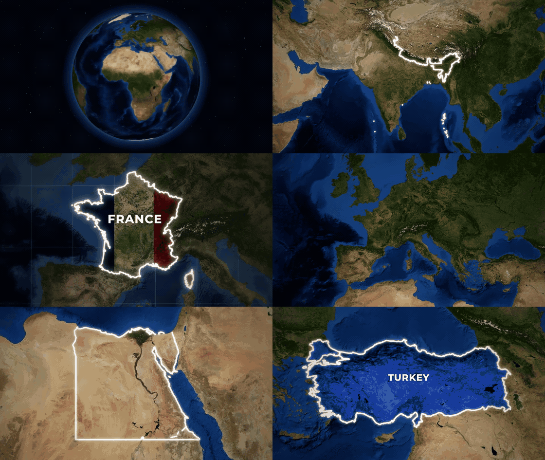
Full-quality version: docs/showcase.mp4
npx mapcast quick India -o india.mp4
That is the whole setup. The first run downloads Chromium and map data once (both cached); videos also need ffmpeg.
Ask your AI for it
mapcast is made to be driven by AI tools: you describe the map, the agent writes the scene, mapcast renders it.
"Make a YouTube Short that spins the globe and lands on Brazil with its flag." "Old parchment map of Turkey, zooming in, with Istanbul marked." "Colour these countries by unemployment: Spain 11.4, Greece 9.8, Germany 3.4."
Claude Code (skill and MCP server in one install):
/plugin marketplace add 21prnv/mapcast
/plugin install mapcast@mapcast
Claude Desktop, Cursor, Windsurf, Codex or any MCP client: add this to the client's MCP config.
{
  "mcpServers": {
    "mapcast": { "command": "npx", "args": ["-y", "mapcast", "mcp"] }
  }
}
The server offers render_map (saves the video or image and returns a preview of the final frame, so the agent
can check its work) and preview_map (one frame, to check a scene before rendering). Every option is described
in the tool schema.
Agents that read SKILL.md skills: npx skills add 21prnv/mapcast. The skill is in
skills/mapcast, with 27 worked request-to-scene examples.
What it can do
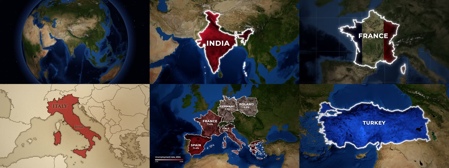
- Styles: colour tint that keeps the terrain visible, spotlight (rest of the world turns grey), outline, or the country's flag laid over its land.
- Basemaps: NASA Blue Marble and Sentinel-2 satellite imagery, or an old parchment map with engraved coasts.
- Cameras: slow push-in, zoom in from a wide view, dive from a spinning 3D globe, fly from country to country.
- Places: every country by name or ISO code, plus 4,500 states and provinces (
"California","IN-MH"), with capitals or any city marked. - Data maps: colour countries by a number with a legend, with names and values on the map.
- Formats: MP4, GIF, PNG, JPG in 16:9, 9:16, 1:1 or 4:5.
- Disputed borders: drawn the way the highlighted country officially draws them, or a neutral view on request.
Command line
npx mapcast quick "United States" --style highlight --color yellow -o usa.png
npx mapcast quick France --style flag -o france.mp4
npx mapcast quick Brazil --camera globe -o brazil.mp4          # dive in from a spinning Earth
npx mapcast quick India France Japan --camera fly -o tour.mp4   # fly from country to country
npx mapcast quick Italy --basemap paper -o italy.mp4

npx mapcast render scene.json -o out.mp4        # any scene; .mp4, .gif, .png or .jpg
npx mapcast render scene.json -o out.png --at 1.2
cat scene.json | npx mapcast render - -o out.gif
npx mapcast schema                              # the scene format as JSON Schema
npx mapcast mcp                                 # MCP server on stdio
Every file in examples/ renders as-is.
Scene format
{
  "aspect": "16:9",
  "duration": 5,
  "camera": "push-in",
  "highlights": [
    { "country": "India", "style": "solid", "color": "#c8102e", "label": "INDIA" }
  ]
}
| Field | Values | Default |
|---|---|---|
aspect |
16:9, 9:16, 1:1, 4:5 (or set width/height) |
16:9 |
duration |
seconds | 5 (7 for globe, 1 + 3 per country for fly) |
fps |
frames per second | 30 |
camera |
push-in, zoom-in, globe (3D Earth dive), fly (country to country), static, or { "move", "fill", "from" } |
push-in |
basemap |
satellite, bluemarble, sentinel, paper (old parchment map) |
satellite |
pov |
auto (the country's own official borders), default, or a code like ind, chn, pak |
auto |
effects.grade |
natural, muted, mono |
natural |
effects.vignette |
0 to 1 | 0.45 |
effects.blur |
0 to 1: soft-focus edges, like a camera lens | 0 |
effects.grid |
true or { "step", "color", "opacity" }: lat/long grid over the sea only |
off |
effects.borders |
true: thin borders of neighbouring countries |
on for paper and states |
labelAnim |
default label animation for every highlight | rise |
Each highlight:
| Field | Values | Default |
|---|---|---|
country |
name ("India") or ISO code ("IN", "IND") |
country or region required |
region |
a state or province: "California", "Bavaria", "US-CA", "IN-MH" |
|
style |
solid (tinted fill), highlight (rest of the world goes grey), outline, flag (the country's flag over the terrain) |
solid |
color |
any CSS colour or red, yellow, blue, ... |
a distinct colour per country |
label |
text, or false for none |
the country name |
border |
{ "color", "width", "glow" } or false |
white, glowing |
labelAnim |
rise, type (typewriter), spread (letters close in), slide, pop |
rise |
labelSize |
multiplier on the automatic label size, e.g. 0.7 or 1.3 |
1 |
labelFont |
sans, serif, or any font name |
sans (serif on paper) |
capital |
true for the capital (a state's own capital for region), or a city name like "Mumbai" |
off |
start |
seconds when this country starts animating | staggered automatically |
Data maps
Colour countries by a number, with a legend:
{
  "data": {
    "title": "GDP 2024 (trillion US$)",
    "prefix": "$",
    "unit": "T",
    "scheme": "heat",
    "values": { "India": 3.9, "China": 18.7, "Japan": 4.1 }
  }
}
scheme is one of reds, blues, greens, heat, purples, diverging, or a list of colours.
Set "labels" to "name", "value" (the number with prefix/unit) or "both" to label each country,
and min/max to fix the colour range. A highlight's label can have a second line: "INDIA\n1.4 BILLION".
How it works
A scene is resolved against Natural Earth borders, the imagery tiles the camera path needs are fetched and cached, and a headless Chromium draws each frame on a canvas (WebGL for the globe). Frames are piped to ffmpeg. A 5 second 1080p clip takes about 15 seconds on a laptop.
Credits and licence
MIT. Map data, imagery and font licences are in NOTICE.md. Satellite imagery needs a credit line wherever you publish; mapcast prints the exact line after every render.
Contributions are welcome: see CONTRIBUTING.md.
mapcast MCP soruları
mapcast MCP'yi Claude Code'a nasıl eklerim?
Terminalinizde claude mcp add mapcast -- npx -y mapcast komutunu çalıştırın. Her projede kullanılabilir olması için --scope user ekleyin.
mapcast MCP'yi Cursor'a nasıl eklerim?
~/.cursor/mcp.json dosyasını açın ve yukarıdaki yükleme bölümünde gösterilen Cursor yapılandırmasını kullanarak sunucuyu mcpServers altına ekleyin.
mapcast'i bir AI agent ile nasıl kullanabilirim?
Sunucuyu MCP konfigürasyonunuza ekleyerek Claude Desktop, Cursor veya Windsurf gibi MCP istemcilerine dahil edebilirsiniz.
Ne tür harita stilleri mevcut?
Mevcut stiller arasında renk tonları, dünyanın geri kalanını grileştiren spot ışıkları, dış hatlar ve bir ülkenin bayrağını topraklarına bindirme seçenekleri bulunur.
Veri odaklı haritalar oluşturabilir miyim?
Evet, çeşitli renk şemalarını kullanarak ülkeleri sayısal değerlere göre renklendirebilir ve başlıklar ile birimler içeren bir lejant ekleyebilirsiniz.
Hangi dosya formatlarını destekliyor?
Araç; MP4, GIF, PNG ve JPG formatlarında video ve görüntü oluşturmayı destekler.