
Mapbox API를 사용하여 AI agent가 지오코딩, POI 검색, 경로 탐색, 등시선(isochrone) 생성 및 대화형 지도 렌더링을 수행할 수 있도록 지원합니다.
다른 이름 mapbox/mcp-server, @mapbox/mcp-server
- 스타
- 370
- Tools
- 1
- 다운로드, 30일
- —
- 최신 버전
- 0.18.0
- 마지막 커밋
- 2026년 11월 13일
- 라이선스
- MIT
Mapbox MCP란?
Mapbox은(는) MCP server입니다. Mapbox API를 사용하여 AI agent가 지오코딩, POI 검색, 경로 탐색, 등시선(isochrone) 생성 및 대화형 지도 렌더링을 수행할 수 있도록 지원합니다. 1개 도구를 제공합니다. 예: uri.
프로젝트 README에서 생성된 요약
Mapbox MCP server 정보
이 server는 Mapbox API에 직접 접근하여 AI agent에게 지리 공간 인텔리전스를 제공합니다. 개발자는 호스팅된 엔드포인트에 연결하거나 Node.js server를 로컬에서 실행하여 Claude Desktop, VS Code, Cursor, Goose와 같은 클라이언트에 위치 인식 기능을 통합할 수 있습니다. 요청 인증 및 위치 데이터 접근을 위해 Mapbox access token이 필요합니다.
이 server는 글로벌 지오코딩, 자동차 또는 자전거를 위한 멀티모달 경로 탐색, 도달 가능 영역을 시각화하는 등시선 생성 등 광범위한 전문 도구를 제공합니다. 또한 agent가 채팅 인터페이스 내에 대화형 Mapbox GL JS 지도나 정적 이미지를 직접 표시할 수 있는 render_map_tool을 포함합니다. API 비용 없이 공간 분석이 필요한 개발자를 위해 Turf.js를 사용하여 거리, 면적, 방위 및 버퍼를 계산하는 오프라인 도구도 제공합니다.
단순한 검색을 넘어, 이 server는 여러 경유지에 대한 경로 최적화나 GPS 궤적을 도로 네트워크에 맞추는 맵 매칭(map matching)과 같은 복잡한 물류 작업을 처리합니다. 또한 MCP resources를 통해 Mapbox 카테고리에 접근할 수 있어, agent가 식당이나 호텔 같은 관심 지점(POI)을 필터링하는 데 도움을 줍니다.
활용 사례
- 1이동 범위 시각화AI agent가 특정 주행 시간 내에 도달 가능한 영역을 보여주는 지도를 생성할 수 있습니다.
- 2배송 물류 최적화개발자가 agent에게 여러 주소를 방문하는 가장 효율적인 순서를 찾도록 요청할 수 있습니다.
- 3대화형 지도 렌더링사용자가 agent에게 채팅창 내에 특정 경로의 실시간 대화형 지도를 표시하도록 요청할 수 있습니다.
- 4GPS 데이터 정제agent가 가공되지 않은 좌표 궤적을 받아 더 나은 시각화를 위해 실제 도로 네트워크에 맞게 조정할 수 있습니다.
- 5오프라인 공간 연산 수행개발자가 외부 API 호출 없이 두 지점 사이의 거리를 계산하기 위해 이 server를 사용할 수 있습니다.
프로젝트의 README를 바탕으로 작성되었습니다. 모든 활용 사례는 해당 내용의 인용문과 대조하여 확인합니다.
Mapbox MCP 설치 방법
형식 확인: 2026년 11월 10일Claude Code에 Mapbox MCP 설치
$ claude mcp add --env MAPBOX_ACCESS_TOKEN=<YOUR_MAPBOX_ACCESS_TOKEN> mcp-server -- npx -y @mapbox/mcp-serverCursor에 Mapbox MCP 설치
~/.cursor/mcp.json
{
  "mcpServers": {
    "mcp-server": {
      "command": "npx",
      "args": [
        "-y",
        "@mapbox/mcp-server"
      ],
      "env": {
        "MAPBOX_ACCESS_TOKEN": "<YOUR_MAPBOX_ACCESS_TOKEN>"
      }
    }
  }
}VS Code에 Mapbox MCP 설치
.vscode/mcp.json
{
  "servers": {
    "mcp-server": {
      "type": "stdio",
      "command": "npx",
      "args": [
        "-y",
        "@mapbox/mcp-server"
      ],
      "env": {
        "MAPBOX_ACCESS_TOKEN": "<YOUR_MAPBOX_ACCESS_TOKEN>"
      }
    }
  }
}Claude Desktop에 Mapbox MCP 설치
claude_desktop_config.json
{
  "mcpServers": {
    "mcp-server": {
      "command": "npx",
      "args": [
        "-y",
        "@mapbox/mcp-server"
      ],
      "env": {
        "MAPBOX_ACCESS_TOKEN": "<YOUR_MAPBOX_ACCESS_TOKEN>"
      }
    }
  }
}Codex에 Mapbox MCP 설치
~/.codex/config.toml
[mcp_servers.mcp-server]
command = "npx"
args = ["-y", "@mapbox/mcp-server"]

[mcp_servers.mcp-server.env]
MAPBOX_ACCESS_TOKEN = "<YOUR_MAPBOX_ACCESS_TOKEN>"
Gemini CLI에 Mapbox MCP 설치
~/.gemini/settings.json
{
  "mcpServers": {
    "mcp-server": {
      "command": "npx",
      "args": [
        "-y",
        "@mapbox/mcp-server"
      ],
      "env": {
        "MAPBOX_ACCESS_TOKEN": "<YOUR_MAPBOX_ACCESS_TOKEN>"
      }
    }
  }
}Mapbox MCP 도구 1
README에서 감지됨uri
| uri | — |
구성
MAPBOX_ACCESS_TOKEN필수비밀Your Mapbox access token
CLIENT_NEEDS_RESOURCE_FALLBACK
| 이름 | 설명 | 유형 |
|---|---|---|
| MAPBOX_ACCESS_TOKEN | Your Mapbox access token | 필수비밀 |
| CLIENT_NEEDS_RESOURCE_FALLBACK | — |
자동 검사
2026년 11월 12일에 실행됨전체 보고서 →자동 검사를 통과했습니다. 이는 보안 감사가 아닙니다. 코드를 직접 읽고 서버에 필요한 최소한의 권한만 부여하십시오. 검사 방식

- 소스 저장소 연결 및 접근 가능통과
- 오픈 소스 라이선스 (OSI)통과
- 최근 1년 내 커밋 또는 릴리스통과
- 패키지 이름이 인기 패키지와 유사하지 않음통과
- 원격 엔드포인트가 HTTPS 사용통과
- 파괴적인 도구에 라벨 표시됨통과
- 모델에 대한 숨겨진 지침 없음통과
- 패키지와 의존성에 심각한 보안 권고 없음통과
README
GitHub에서 보기Mapbox MCP Server

Node.js server implementing Model Context Protocol (MCP) for Mapbox APIs.
Unlock Geospatial Intelligence for Your AI Applications
The Mapbox MCP Server transforms any AI agent or application into a geospatially-aware system by providing seamless access to Mapbox's comprehensive location intelligence platform. With this server, your AI can understand and reason about places, navigate the physical world, and access rich geospatial data including:
- Global geocoding to convert addresses and place names to coordinates and vice versa
- Points of interest (POI) search across millions of businesses, landmarks, and places worldwide
- Multi-modal routing for driving, walking, and cycling with real-time traffic
- Travel time matrices to analyze accessibility and optimize logistics
- Route optimization to find the optimal visiting order for multiple stops (traveling salesman problem)
- Map matching to snap GPS traces to the road network for clean route visualization
- Isochrone generation to visualize areas reachable within specific time or distance constraints
- Live, interactive map rendering (
render_map_tool) to display routes, search results, and your own custom GeoJSON on a real Mapbox GL JS map directly inside the chat - Static map images to create visual representations of locations, routes, and geographic data
- Offline geospatial calculations for distance, area, bearing, buffers, and spatial analysis without requiring API calls
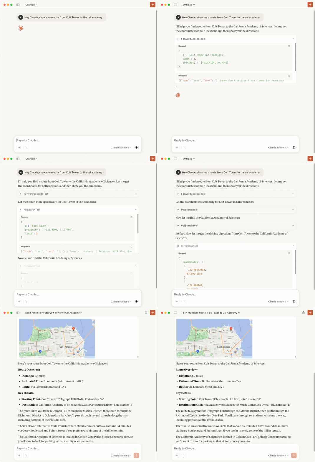
Whether you're building an AI travel assistant, logistics optimizer, location-based recommender, or any application that needs to understand "where", the Mapbox MCP Server provides the spatial intelligence to make it possible. You can also enable it on popular clients like Claude Desktop and VS Code. See below for details
Usage
A Mapbox access token is required to use this MCP server.
Hosted MCP Endpoint
For quick access, you can use our hosted MCP endpoint:
Endpoint: https://mcp.mapbox.com/mcp
For detailed setup instructions for different clients and API usage, see the Hosted MCP Server Guide.
To get a Mapbox access token:
- Sign up for a free Mapbox account at mapbox.com/signup
- Navigate to your Account page
- Create a new token or use the default public token
For more information about Mapbox access tokens, see the Mapbox documentation on access tokens.
Integration Guides
For detailed setup instructions for different integrations, refer to the following guides:
- Claude Desktop Setup - Instructions for configuring Claude Desktop to work with this MCP server
- Goose Setup - Setting up Goose AI agent framework
- VS Code Setup - Setting up a development environment in Visual Studio Code
- Cursor AI IDE Setup - Setting up a development environment in Cursor AI IDE
- Smolagents Integration - Example showing how to connect Smolagents AI agents to Mapbox's tools
- Importing Tools Directly - Use Mapbox tools in your own applications without running the MCP server
render_map_toolGuide - The map visualization primitive: full payload schema and how to render your own data standalone, without any other Mapbox tool- Elicitations - How
search_and_geocode_toolanddirections_toolask the user to disambiguate results or pick a route, and how they fall back gracefully when the client doesn't support it
Example Prompts
Try these prompts with Claude Desktop or other MCP clients after setup:
Location Grounding
For coordinate-first queries — "what's near me", "what neighborhood is this", "what's reachable in N minutes" — use ground_location_tool. It composes reverse geocoding, category search, and isochrone in a single call, adaptively choosing the right strategy based on the query, and returns typed records (names, addresses, coordinates, distances, reachability polygons) with citations.
Each of the four prompts below exercises a different strategy in one tool call:
- Neighborhood — "What neighborhood is 47.6097, -122.3408, and what's around me?"
- POI — "Coffee shops within a 10-minute walk of 40.7580, -73.9855"
- Region — "What can I reach in a 15-minute walk from 37.7749, -122.4194?"
- Routing — "Closest routable point to drop someone off at 34.0522, -118.2437"
Location Discovery
- "Find coffee shops within walking distance of the Empire State Building"
- "I want to go from Seattle to Portland, is there a Starbucks along the way?"
- "Show me gas stations along the route from Boston to New York"
- "What restaurants are near Times Square?"
Navigation & Travel
- "Get driving directions from LAX to Hollywood with current traffic"
- "How long would it take to walk from Central Park to Times Square?"
- "Calculate travel time from my hotel (Four Seasons) to JFK Airport by taxi during rush hour"
Visualization & Maps
- "Using the Mapbox map render tool, show me directions from the Golden Gate Bridge to Union Square in San Francisco" — renders a live, interactive route on a real Mapbox map
- "Create a map image showing the route from Golden Gate Bridge to Fisherman's Wharf with markers at both locations"
- "Show me a satellite view of Manhattan with key landmarks marked"
- "Generate a map highlighting all Starbucks locations within a mile of downtown Seattle"
- "Show a fill polygon over these coordinates: [...], with a marker labeled 'Warehouse' at [...]" — renders your own GeoJSON directly via
render_map_tool, no other Mapbox tool needed
Analysis & Planning
- "Show me areas reachable within 30 minutes of downtown Portland by car"
- "Calculate a travel time matrix between these 3 hotel locations (Marriott, Sheraton and Hilton) and the convention center in Denver"
- "Find the optimal route visiting these 3 tourist attractions (Golden Gate, Musical Stairs and Fisherman's Wharf) in San Francisco"
- "Optimize a delivery route for these 8 addresses: [list of addresses]"
GPS & Route Matching
- "Clean up this GPS trace and show the actual route on roads: [list of coordinates with timestamps]"
- "Snap this recorded bicycle ride to the cycling network: [GPS coordinates]"
- "Match this driving route to the road network and show traffic congestion levels"
Offline Geospatial Calculations
- "What's the distance in miles between these two coordinates?"
- "Calculate the area of this polygon in square kilometers"
- "Is the point at 37.7749°N, 122.4194°W inside this service area polygon?"
- "What's the bearing from San Francisco to New York?"
- "Find the midpoint between London and Paris"
- "Create a 5-mile buffer zone around this location"
- "Calculate the centroid of this neighborhood boundary"
- "What's the bounding box for these route coordinates?"
- "Simplify this complex polygon to reduce the number of points"
Tips for Better Results
- Be specific about locations (use full addresses or landmark names)
- Specify your preferred travel method (driving, walking, cycling)
- Include time constraints when relevant ("during rush hour", "at 3 PM")
- Ask for specific output formats when needed ("as a map image", "in JSON format")
Detailed examples: See examples/search-along-route.md for comprehensive examples of the search-along-route prompt with different use cases and MCP Inspector testing instructions.
Resources
The MCP server exposes static reference data as MCP resources. Resources provide read-only access to data that clients can reference directly without making tool calls.
Available Resources
Mapbox Categories Resource
URI Pattern: mapbox://categories or mapbox://categories/{language}
Access the complete list of available category IDs for use with the category search tool. Categories can be used to filter search results by type (e.g., "restaurant", "hotel", "gas_station").
Examples:
mapbox://categories- Default (English) category listmapbox://categories/ja- Japanese category namesmapbox://categories/es- Spanish category names
Accessing Resources:
- Clients with native MCP resource support: Use the
resources/readMCP protocol method - Clients without resource support: Use the
resource_reader_toolwith the resource URI
Rich Map Previews (render_map_tool)
Every geospatial tool in this server (directions, isochrone, search, and more) can display its result as a live, interactive Mapbox GL JS map via render_map_tool — the server's single visualization primitive. It renders through the MCP Apps protocol (@modelcontextprotocol/ext-apps) as a self-contained HTML panel directly inside the chat, with a Fullscreen toggle, in supported clients:
- Claude Desktop ✅
- VS Code with GitHub Copilot ✅
- Claude Code ✅
- Goose ✅
You don't need any of this server's other tools to use it. render_map_tool also accepts hand-composed GeoJSON directly — your own polygons, markers, and routes — with no dependency on directions_tool, isochrone_tool, or any other Mapbox API call. See the full render_map_tool guide for the payload schema and a complete standalone example.
If you need a guaranteed static image in clients without MCP Apps support, use static_map_image_tool instead — it returns a base64-encoded PNG/JPEG that every client can display.
CLIENT_NEEDS_RESOURCE_FALLBACK
Resource Fallback Tools (Opt-In for Non-Compliant Clients)
Resources are a core MCP feature supported by most clients (Claude Desktop, VS Code, MCP Inspector, etc.). However, some clients (like smolagents) don't support resources at all. For these clients, the server can provide "resource fallback tools" that deliver the same content as resources but via tool calls.
Fallback Tools:
resource_reader_tool- Generic fallback for reading any resource by URIcategory_list_tool- Provides access to category list (mapbox://categories)
By default, these tools are NOT included (assumes your client supports resources). If your client doesn't support resources, enable the fallback tools:
export CLIENT_NEEDS_RESOURCE_FALLBACK=true
When to set this:
- ✅ Set to
trueif using smolagents or other clients without resource support - ❌ Leave unset (default) if using Claude Desktop, VS Code, MCP Inspector, or any resource-capable client
- ❌ Leave unset if unsure (most clients support resources)
Tools
Utility Tools
Resource Reader Tool
Provides access to MCP resources for clients that don't support the native MCP resource API. Use this tool to read resources like the category list.
Parameters:
uri: The resource URI to read (e.g.,mapbox://categories,mapbox://categories/ja)
Example Usage:
- Read default categories:
{"uri": "mapbox://categories"} - Read Japanese categories:
{"uri": "mapbox://categories/ja"}
Note: If your MCP client supports native resources, prefer using the resource API directly for better performance.
Offline Geospatial Tools
These tools perform geospatial calculations completely offline without requiring Mapbox API calls. They use Turf.js for accurate geographic computations and work anywhere, even without internet connectivity.
Distance Tool
Calculate the distance between two geographic coordinates using the Haversine formula.
Features:
- Supports multiple units: kilometers, miles, meters, feet, nautical miles
- Accurate great-circle distance calculation
- No API calls required
Example Usage: "What's the distance between San Francisco (37.7749°N, 122.4194°W) and New York (40.7128°N, 74.0060°W)?"
Points Within Polygon Tool
Test one or more points against a polygon or multipolygon, returning only those inside. Handles a single point or a batch in one call.
Features:
- Works with complex polygons including holes
- Supports multipolygons
- Batch-tests any number of points in one call
- Useful for geofencing, delivery zone validation, and customer segmentation
Example Usage: "Which of these delivery addresses are inside our service area?"
Destination Tool
Calculate a destination point given a starting point, bearing, and distance using geodesic (great-circle) offset.
Features:
- Straight-line offset, not a routed path
- Useful for "find a point 5km north of X" or constructing search offsets
- No API calls required
Example Usage: "What's the point 10km northeast of the Space Needle?"
Bearing Tool
Calculate the compass direction (bearing) from one coordinate to another.
Features:
- Returns bearing in degrees (0-360°)
- Provides cardinal direction (N, NE, E, SE, S, SW, W, NW)
- Useful for navigation and directional queries
Example Usage: "What direction should I head to go from here to the airport?"
Midpoint Tool
Find the geographic midpoint between two coordinates along the great circle path.
Features:
- Calculates true midpoint on Earth's curved surface
- Useful for meeting point suggestions
- Handles long-distance calculations correctly
Example Usage: "What's halfway between San Francisco and New York?"
Centroid Tool
Calculate the geometric center (centroid) of a polygon or multipolygon.
Features:
- Works with complex shapes
- Returns arithmetic mean of all points
- Useful for placing labels or markers
Example Usage: "Where should I place a marker for this neighborhood boundary?"
Area Tool
Calculate the area of a polygon.
Features:
- Supports multiple units: square meters, square kilometers, acres, hectares, square miles, square feet
- Accurate area calculation on Earth's surface
- Works with polygons of any size
Example Usage: "What's the area of this park in acres?"
Bounding Box Tool
Calculate the minimum bounding box (bbox) that contains a geometry.
Features:
- Works with points, lines, polygons, and multipolygons
- Returns [minLongitude, minLatitude, maxLongitude, maxLatitude]
- Useful for viewport calculations and spatial indexing
Example Usage: "What's the bounding box for this route?"
Buffer Tool
Create a buffer zone (polygon) around a point, line, or polygon.
Features:
- Supports multiple distance units
- Creates circular buffers around points
- Useful for proximity analysis and creating zones of influence
Example Usage: "Show me a 5km buffer zone around this location"
Simplify Tool
Reduce the number of vertices in a line or polygon using the Douglas-Peucker algorithm.
Features:
- Configurable tolerance for detail level
- Preserves overall shape while reducing complexity
- Useful for reducing file sizes and improving rendering performance
- Option to maintain topology (prevent self-intersections)
Example Usage: "Simplify this complex boundary to reduce the number of points"
Length Tool
Measure the total length of a line defined by a series of coordinates.
Features:
- Supports kilometers, miles, meters, and feet
- Useful for measuring a drawn route, path, or boundary without a routing API call
Example Usage: "How long is this hiking trail?"
Convex Tool
Compute the convex hull of a set of points — the smallest convex polygon containing all of them.
Features:
- Useful for bounding-area analysis or estimating coverage area
- Works offline without API calls
Example Usage: "What's the smallest polygon that contains all of these store locations?"
Nearest Point Tool
Find the nearest point in a collection to a given target point.
Features:
- More efficient than calling
distance_toolfor each candidate and sorting - Useful for finding the closest store, stop, or landmark to a location
Example Usage: "Which of these stores is closest to my current location?"
Nearest Point on Line Tool
Snap a point to the nearest position on a line or route, returning that point and the distance to it.
Features:
- Useful for "which point on this route is closest to my location?" or map-matching without an API call
Example Usage: "Where on this hiking trail am I closest to right now?"
Union, Intersect, and Difference Tools
Combine or compare two or more polygons — union_tool merges them into one geometry, intersect_tool finds the area they share, and difference_tool subtracts one from another.
Features:
- Useful for combining service areas, finding coverage overlap, or computing exclusion zones (e.g. "what's covered by zone A but not zone B?")
- Works entirely offline — no API calls required
- Each returns a
render_map_toolreference so the result can be visualized directly
Example Usage: "Combine these two delivery zones into one coverage area" / "Where do these two isochrones overlap?" / "What part of this service area isn't covered by our 15-minute isochrone?"
Mapbox API Tools
Category List Tool (Deprecated)
⚠️ Deprecated: Use the resource_reader_tool with URI mapbox://categories instead, or access the mapbox://categories resource directly if your client supports MCP resources.
This tool is maintained for backward compatibility with clients that don't support MCP resources or the resource_reader_tool.
Matrix Tool
Calculates travel times and distances between multiple points using Mapbox Matrix API. Features include:
- Efficient one-to-many, many-to-one or many-to-many routing calculations
- Support for different travel profiles (driving-traffic, driving, walking, cycling)
- Departure time specification for traffic-aware calculations
- Route summarization with distance and duration metrics
- Control approach (curb/unrestricted) and range of allowed departure bearings
Static image tool
Generates static map images using the Mapbox static image API. Features include:
- Custom map styles (streets, outdoors, satellite, etc.)
- Adjustable image dimensions and zoom levels
- Support for multiple markers with custom colors and labels
- Overlay options including polylines and polygons
- Auto-fitting to specified coordinates
Category search tool
Performs a category search using the Mapbox Search Box category search API. Features include:
- Search for points of interest by category (restaurants, hotels, gas stations, etc.)
- Filtering by geographic proximity
- Customizable result limits
- Rich metadata for each result
- Support for multiple languages
Reverse geocoding tool
Performs reverse geocoding using the Mapbox geocoding V6 API. Features include:
- Convert geographic coordinates to human-readable addresses
- Customizable levels of detail (street, neighborhood, city, etc.)
- Results filtering by type (address, poi, neighborhood, etc.)
- Support for multiple languages
- Rich location context information
Ground location tool
Answers "what's near this coordinate" questions in a single call — place name, nearby points of interest, and travel-time reachability — sourced from live Mapbox data with citations. Use this instead of chaining reverse_geocode_tool with a web search.
Features:
- Classifies the query (routing, neighborhood context, POI search, or region/reachability) and fetches only the relevant data
- Nearby POI search by category, when requested
- Travel-time reachability summary (isochrone-based)
- Returns a
render_map_toolreference with the grounded location and nearby POIs plotted
Example Usage: "What neighborhood is this coordinate in, and are there any coffee shops nearby?"
Place details tool
Retrieves detailed information about a specific place using its Mapbox ID — photos, opening hours, ratings, phone numbers, and website URLs. Use after search_and_geocode_tool, category_search_tool, or reverse_geocode_tool to get more detail on a specific result.
Example Usage: "Tell me more about that first coffee shop result — hours, phone number, and website"
Directions tool
Fetches routing directions using the Mapbox Directions API. Features include:
- Support for different routing profiles: driving (with live traffic or typical), walking, and cycling
- Route from multiple waypoints (2-25 coordinate pairs)
- Alternative routes option
- Route annotations (distance, duration, speed, congestion)
- Scheduling options:
- Future departure time (
depart_at) for driving and driving-traffic profiles - Desired arrival time (
arrive_by) for driving profile only
- Future departure time (
- Profile-specific optimizations:
- Driving: vehicle dimension constraints (height, width, weight)
- Exclusion options for routing:
- Common exclusions: ferry routes, cash-only tolls
- Driving-specific exclusions: tolls, motorways, unpaved roads, tunnels, country borders, state borders
- Custom point exclusions (up to 50 geographic points to avoid)
- GeoJSON geometry output format
Isochrone tool
Computes areas that are reachable within a specified amount of times from a location using Mapbox Isochrone API. Features include:
- Support for different travel profiles (driving, walking, cycling)
- Customizable travel times or distances
- Multiple contour generation (e.g., 15, 30, 45 minute ranges)
- Optional departure or arrival time specification
- Color customization for visualization
Search and geocode tool
Uses the Mapbox Search Box Text Search API endpoint to power searching for and geocoding POIs, addresses, places, and any other types supported by that API. This tool consolidates the functionality that was previously provided by the ForwardGeocodeTool and PoiSearchTool (from earlier versions of this MCP server) into a single tool.
Map matching tool
Snaps GPS traces to the road network using the Mapbox Map Matching API. Features include:
- Convert noisy GPS traces to clean routes on the road network
- Support for different travel profiles (driving, driving-traffic, walking, cycling)
- Handle up to 100 coordinate pairs per request
- Optional timestamps for improved accuracy based on speed
- Configurable snap radiuses for different GPS quality levels
- Route annotations (speed limits, distance, duration, traffic congestion)
- Multiple geometry output formats (GeoJSON, polyline)
Example Usage: "Clean up this GPS trace and snap it to roads: [coordinates with timestamps]"
Mapbox MCP 질문
Mapbox MCP를 Claude Code에 추가하려면 어떻게 하나요?
터미널에서 claude mcp add --env MAPBOX_ACCESS_TOKEN=<YOUR_MAPBOX_ACCESS_TOKEN> mcp-server -- npx -y @mapbox/mcp-server를 실행합니다. 모든 프로젝트에서 사용할 수 있게 하려면 --scope user를 추가합니다.
Mapbox MCP를 Cursor에 추가하려면 어떻게 하나요?
~/.cursor/mcp.json를 열고 mcpServers 아래에 서버를 추가합니다. 위 설치 섹션에 표시된 Cursor 구성을 사용합니다.
Mapbox MCP는 어떤 도구를 제공하나요?
1개 도구를 제공합니다. 예: uri.
Mapbox MCP server를 사용하려면 무엇이 필요한가요?
이 MCP server를 사용하려면 Mapbox access token이 필요합니다.
채팅 인터페이스에서 지도를 직접 시각화할 수 있나요?
네, render_map_tool을 통해 지원되는 채팅 클라이언트 내에서 경로, 검색 결과 및 사용자 정의 GeoJSON을 실시간 대화형 지도로 렌더링할 수 있습니다.
모든 지리 공간 계산에 인터넷 연결이 필요한가요?
아니요, API 호출 없이도 Turf.js를 사용하여 거리, 면적, 방위 및 공간 분석을 수행할 수 있는 오프라인 지리 공간 도구를 포함하고 있습니다.